Vittorio Salmoni, Mario Piccinini, INU – URBIT
The Adriatic city of Romagna
The Riviera Romagnola goes from the mouth of the river Reno to the promontory of Gabicce Monte, crossing the provinces of Ravenna, Forlì-Cesena and Rimini.
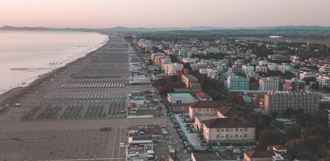
The “Adriatic city”, along the coast of Romagna, was formed in the 1950s with the expansion of Rimini and Milano Marittima and the creation of the beaches of Romagna, consisting of a continuous beach extending for 130 kilometres, characterised to the north by the landscape of the Po Delta, to the south by the Adriatic conurbation of Romagna for 70 kilometres.
The urban structure is formed by State Road 16 which runs parallel to the coast and by the railway line, a barrier to pass from the road to the sea. To these is added the A 14 motorway, which also acts as a ring road to connect the municipalities of the conurbation.
The Adriatic city of the Marches
The development of the axis along the coast led to a rapid process of urbanization towards the coast with an imbalance in the demographic structure that had been evenly distributed until then. The thickening has not generated large cities: the most populated reach only 100 thousand inhabitants (14% of the population).
Infrastructures have also developed, generating the linear city, which has now reached saturation. The particular morphology of the Region has prevented the urban ribbon from having continuity: the pauses of the transversal valley intersections fragment the linear layout and are arranged as gates to the internal areas. The coastal urbanisation of the Marche region is configured from Gabicce to Falconara Marittima as the continuation of the settlement model of Romagna, dragged by the powerful development of the tourist activity of that pole. In the centre, the 12 miles of the Conero cliff, constitute a uniqueness for the entire Adriatic coast and the strongest discontinuity of the linear layout where urban models, scattered villages set on the slopes of the Mount, naturalistic areas, countryside, coast, and marinas change structures. From Porto Recanati to S. Benedetto the linear, dense and compact order returns, around urban poles in exponential growth.
PROGRAMME
Introduction:
Mario Piccinini, Vittorio Salmoni, INU – URBIT
Presentation of projects by municipalities on the Romagna and Marche coasts:
Municipality of Cattolica
Fausto Battistel, Councillor for Urban Planning, Municipality of Cattolica
StrategicAncona 2025: Ancona a contemporary city of the sea
Claudio Centanni, City Planning Director of the Municipality of Ancona, President of INU Marche Section
Interreg Italy – Croatia “Joint_SECAP”: Strategies and joint actions for the adaptation to climate change of the Adriatic Sea city
Rosalba D’Onofrio, Unicam-School of Architecture and Design
Conclusions:
Mario Piccinini, Vittorio Salmoni, INU – URBIT
Italiano
Contributions